Very Cold November Pattern With Snow Chances Too
It was not that long ago that we were talking about endless summer…highs in the 80s were common early in October and air conditioners were still humming. November is getting underway with a much different flavor. Let’s touch on some specifics.
THURSDAY’S SNOW CHANCE
A cold front will cross the area Thursday morning and the temperature is expected to drop some throughout the day. Meanwhile, some moisture will “overrun” that front, leading to rising air and precipitation. It will take a while for the air up above our heads to cool sufficiently for snow production. That should occur at some point in the afternoon or evening. A changeover to wet snow will occur but honestly I don’t think we are in for much accumulation around here. The best moisture will be leaving us by the time it finally gets cold enough.
Simulated radar for the next few days:
Lake-effect flurries and snow showers will fly for a while into Friday morning. Local lake-effect accumulations will not be anything significant. Maybe an extra coating to an inch in northern Trumbull/Mercer.
Odds of 1” or more of snow Thursday into Thursday night (legend in lower left):
Odds of 2” or more:
National Weather Service snow forecast through 7am Friday:
THE NEXT COLD SHOT
The arctic front that will cross The Valley Sunday/Sunday night is very impressive-looking for this time of year. It will usher in some serious cold for at least the first half of next week. It’s November so the Great Lakes are still quite mild compared to the air that will be blowing over them so lake-effect should be plentiful next week in the usual favored areas. Wintry-looking weather map next Tuesday:
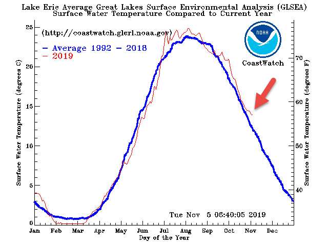
Water temperatures on Lake Erie are running above-average by a few degrees.
THIS COLD SNAP HAS SOME LEGS!
Waves of cold will plunge south over the next 10 days to 2 weeks. If this were January we’d be talking about several subzero temperatures and nasty wind chills.
DOES THIS MEAN ANYTHING FOR WINTER?
It seems quite likely that, compared to average, November will be the coldest month of 2019. Only one month has been colder-than-average this year (March). Actually, for as much warming as our area has seen in recent years, we have had a fair amount of cold Novembers this decade. The last 3 have been cold and 6 of the last 8 have been below the average (black line).
Does a cold November correlate to a cold winter?? Well, as with many things weather…the answer is complicated. More often than not, yes, a VERY cold November is followed by a colder-than-average winter. Here’s a composite of the winters that followed our top 10 coldest Novembers:
However, November 2018 was the 7th coldest November on record and the winter that followed was….ho hum. Mild December, typical January and warm February here.
WINTER FORECAST SOON!
May annual winter forecast will debut on 21 News at 6pm Thursday, with an encore at 11pm. Plus the long, geeks, detailed version will be posted online. More of a reader? I’ll have a written blog post (much like this one) here as well.


