2019-2020 Winter Forecast
The LONG(LONG!) video version is here and/or you can check out the written version below. Leave a comment! Do you like the forecast??
It’s time once again for my annual winter forecast. It’s reasonable to ask: how good are these forecasts? Can you really do this?
The answer is YES. There is skill in these predictions. Is the skill as high as your typical 7-day forecast? No way. But there is a lot more skill in seasonal predictions than a total guess. This isn’t throwing darts. A good seasonal outlook has lots and lots of science behind it.
That being said, a case can be made that these outlooks are getting somewhat MORE difficult, despite advances in technology and knowledge. Why is that? Well a large part of creating a seasonal forecast is the reliance on “analogs”: years in which conditions in the atmosphere and oceans are similar to the current year. With the global climate (including ocean temperatures) warming so rapidly, looking at analog years before the 1990s or 2000s may be becoming impractical. The atmosphere was much different 40+ years ago.
LAST WINTER REVIEW
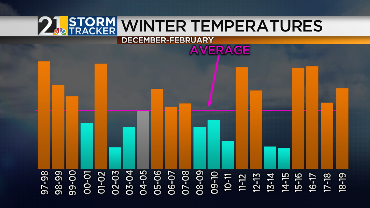
Last winter was a pretty uneventful one overall. December 2018 was mild and featured little snow. January was pretty by-the-books in terms of temperatures and snowfall, with one harsh cold snap at the end of the month. February turned quite mild (as it’s been prone to do in recent years).
We have reeled off 4 consecutive mild winters after back-to-back harsh ones in 2013-2014 and 2014-2015.
2019-2020 WINTER FACTORS
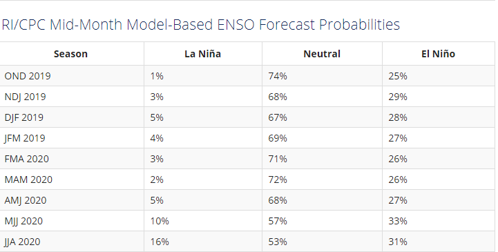
One of the first things we look at when making a winter forecast is: what’s the state of the water temperatures of the equatorial Pacific. This is where we look for El Nino (warm water) and La Nina (cold water). These water temperature anomalies can have a big impact on weather patterns in the northern hemisphere. This year things are looking pretty “neutral”, in other words there’s not much going on in this part of the ocean. A very weak El Nino may be brewing but La Nina is off the table. The most likely phase for the winter is “neutral”.
Another important area to look at is the northern Pacific, where there is a lot of warm water right now. This can encourage a ridge of high pressure to park over that region, which has implications for North America.
It was a wet summer in the Plains and a dry one in the Southeast. So? Well soil moisture can be an important factor when determining where ridges and troughs like to set up as we get into winter. Ridges of high pressure tend to want to hang out over dry areas. The opposite is true for troughs of low pressure.
It can be useful to know what the condition of the sun is. HOT right? Well for the purposes of the forecast, we want to know if the sun is “quiet” (few sunspots) or “active” (lots of sunspots). Why? Recent research shows that a quiet sun can help to encourage blocking patterns in parts of the northern hemisphere during winter. Blocking patterns can result in “stuck” weather patterns where dry/warm regimes and stormy/cold regimes don’t want to break. We are in a solar “minimum” now and likely will be for a few years.
The snow season is off to a fast start across parts of Canada. A deep, well-established snow pack can act as a refrigerant for arctic air masses descending from the high latitudes. Essentially, already cold air masses can be further cooled by traversing a snow-covered landscape.
LET’S GET TO THE FORECAST
Ok, I have gone over SOME of the things that are important pieces to this year’s forecast puzzle. There are many more but I don’t want everyone’s eyes to glaze over. Let’s get to the forecast.
My list of top analogs this year:
A lot of cold winters on that list. A couple of snowy winters and some not-so-snowy ones too. Overall I think 2004-2005 is the best match for this year.
Based on analog and computer model data, here’s the forecast. A wetter-than-average winter in our region:
The temperature forecast features warm weather in the West and the Southeast. Highest chances for a colder-than-average winter will be across the northern Great Lakes and parts of New England. I lean toward an average to perhaps slightly colder-than-average season here.
Given the analogs, this may be a conservative temperature forecast. Why is my forecast not colder? First of all, I really like 2004-2005 as an analog and that was a pretty average winter temperature-wise. Secondly, weak El Nino or neutral winters tend to trend toward recent climatology. What do I mean? Without a strong Nino/Nina signal, a good place to start when making the forecast is averaging together the last handful of winters. Here’s what that map looks like:
In addition, the atmosphere seems to “want” to be warm over our area. March is the only month that has been colder-than-average in 2019 (November should be month #2). 2018 only had 3 cooler-than-average months. You’d have lost a lot of money betting on cold over the last couple of years. Maybe the next few months will be different but until proven otherwise, I’m very hesitant to predict much unusual cold.
Snowfall is likely to be the biggest change from last year. I expect us to see a much snowier winter, with most places averaging 10-20% more snow than average.
Another way to compare last winter and this winter is like this:
IMPACTS
Expect higher energy bills this winter when compared to last, although again I do not think it will be a harsh winter. Salt usage will be higher with more snow on the way. As there are every winter, of course there will be occasional school adjustments.


