Reviewing The Winter & Talking Spring
A LOOK BACK AT METEOROLOGICAL WINTER
As you may know, those of us in the weather biz like to divide up the seasons a bit differently than the traditional “astronomical” way, which are based on the position of Earth in our annual trip around the sun. Those seasons don’t begin at exactly the same time/day every year, which makes for some sloppy record keeping. Our “meteorological” or climatological” seasons are the same every year, which is useful when talking about and comparing weather records..
So, “winter” (December-February) is in the books. How did it go? How was our annual winter forecast? Let’s dive in.
WINTER GOT OFF TO A VERY MILD START
December was a real yawner from a snow and cold standpoint. In fact, it was the 4th warmest December on record in Youngstown. The cold was bottled up out West for most of the month (and even out there…it wasn’t all that cold):
JANUARY: A PATTERN FLIP
Things changed in a big hurry as we welcomed in the near year. A very large ridge of high pressure settled over the West Coast, forcing a deep trough of low pressure to dominate in the East. After reaching a high of 55 degrees on New Year’s Day, we did not come withing a country mile of that kind of temperature for the rest of the month. It ended up being our coldest January in 7 years.
We were not alone in the deep freeze:
FEBRUARY: STORMY BUT NOT AS COLD
February brought about more frequent bouts of seasonable and mild temperatures, but it was an unsettled month with a few impactful winter storms.
SEASONAL SNOW: SURPRISINGLY LOW?
We are not done with snow for the season…we often see bouts of snow into April (and last year, May!), although the last 2 Marches have been uncharacteristically snow-free. This season, we have actually had less snow than average and less snow than last year through the end of February. Surprising, right? It’s been a wintry 6 weeks, but remember…..December was essentially snow-free. At the YNG airport, there was actually more snow in November than December.
GRADING THE WINTER FORECAST
Every year, I release a long range, seasonal outlook right around the first of November. These forecasts are created in a different way than the typical 7-day forecast and naturally are less skillful than those short range prognostications. But there IS skill in these outlooks; it’s not throwing darts. Some meteorologists in the private sector make seasonal forecasts in which big money is at stake. Energy suppliers and commodities traders pay handsomely for these forecasts. Lots of pressure! If there were no skill, they wouldn’t pay for them and the forecasters would be looking for other lines of work.
I’m not employed by that side of the weather biz, but I know my audience is interested in and can derive some value from the long-range forecast. So, how’d we do this year?
Pretty good! With some caveats.
TEMPERATURES
On a national scale, here was the forecast:
Here’s what happened:
PRECIPITATION
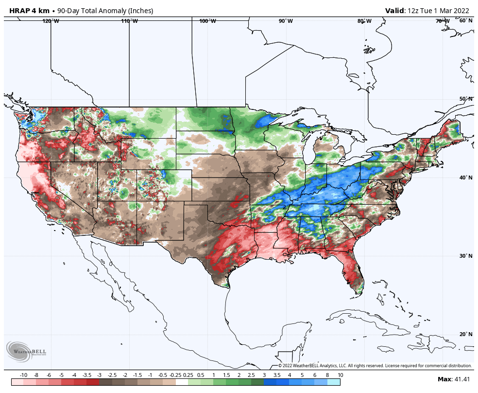
Forecast:
Verification:
Locally, we expected a warmer-than-average season and a wetter than average one too. Snowfall was expected to be below average. All verified! That said, I mentioned caveats. The idea in the forecast was that winter would start cold (very wrong) and end warm (meh). So while it came out in the wash as a good forecast, the sequence was wrong and I am frustrated by that. I won’t get int the meteorological reasons for why this happened, but, just like with any forecast miss, lessons have been learned.
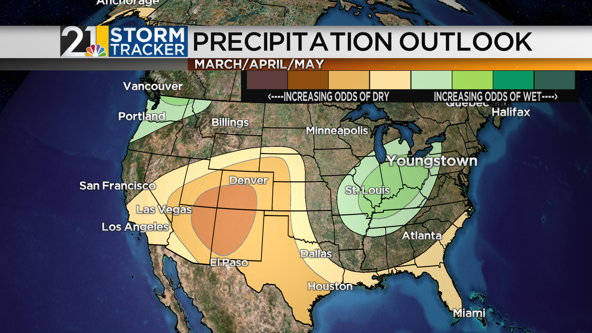
LOOKING AHEAD TO SPRING
Again, we are considering “Meteorological” Spring, or March-May. Our temperature averages climb quickly, as you would expect:
You may recall that, last year, the new 30-year averages were released. Our “averages”, whether they be temperatures, precipitation or most anything else weather-related, are based on 30-year periods. Every 10 years, that 30-year block is rolled forward a decade. So now our averages are based on the years 1991-2020.
While temperatures have warmed considerably in recent years and decades…some months and seasons have seen more warming than others. In Spring, March has not changed much but May has gotten much warmer.
You could think of Spring as our most “extreme” season; it’s the season with the biggest difference between the all-time record low and record high.
This time of the year is “boy the days are getting longer fast!” season. The daylight gain in March alone is nearly 90 minutes; around 2 minutes, 45 seconds per day at the peak around the Vernal Equinox.
Winter of 2021-2022 was a La Nina Winter, in which we had a stout pool of cooler-than-average water in the eastern equatorial Pacific. This cool pocket of water impacts wintertime weather patterns over the Northern Hemisphere. Typically, La Nina (or El Nino) has less of an impact outside of Winter, but it can still be a player in late Fall and early Spring. The La Nina will fade later this season, but I think it will still play the role of “traffic cop” for a while longer. Therefore, the Spring forecast is not that dissimilar than what happened from December-February: a wetter-than-average season seems likely…..and temperatures should shake out as warmer-than-average.
This type of configuration could raise the possibility of an active severe weather season in our region. In 2021, early Spring did NOT bring many opportunities for severe thunderstorms….but we made up for lost ground by very late Spring and Summer. Thunderstorms were even pretty common well into Fall. This year may not be as active in those time periods but early/mid Spring will bear watching.


